
People often ask me during my island tours if there is a beautiful beach they can walk to from Cruz Bay. The answer is yes, and it’s one of the best!
Honeymoon is one of the closest north shore beaches to Cruz Bay. It is very quiet and serene, as you can only access it currently by hiking in via the Lind Point trail or by boat. It’s a decent-sized beach, especially for St. John standards, and it has a nice reef, which is nestled between Honeymoon and Salomon beaches. The walk to Honeymoon via the lower Lind Point trail is roughly a mile, and it takes about 25 minutes or so depending on your pace.
The Lind Point trail starts just behind the National Park’s visitor center in Cruz Bay. If you are not familiar with that building, it is the large yellow building that is located next to the creek and across the street and down a little from Mongoose Junction. Walk behind the visitor center, and you will see a set of stairs. That is where the hike begins.
(If you have a vehicle and plan to park and hike, you have to go into the visitor center to obtain a parking pass. There is not a fee associated with this pass.)


To start the hike to Honeymoon, you will walk up these stairs and then take left at the top. You will see the Caneel Bay apartments to your right and beautiful views of Cruz Bay to your left. You will walk up a small hill, and will quickly see the trail going into the woods on your right.

There is a small incline at the begin of the trail as you walk up the rocky steps and onto the main path. This slight climb lasts only for a few minutes before the trail levels out.
Within just a few minutes of walking, you will come to an intersection with a large rock in the middle. The trail to your right takes you to the upper Lind Point Trail. This trail also leads you to Honeymoon beach, but today we’re sticking to the lower Lind Point trail. So you will want to take a left at this intersection.

As you can see in the photos below, there are some rocky areas along this trail. There are also some spots that are very sunny, and others that are rather overgrown. This trail is definitely doable in flip flops, but it’s a lot easier in sneakers or sandals with straps like Tevas or something similar to that.


After roughly 15 minutes of walking, you will come the trail that leads down to Salomon beach. As you continue walking, you will see another trail that leads slightly uphill on your right. This connects to the upper Lind Point trail. Skip both of those trails and continue forward if you’d like to visit Honeymoon beach.


You will come to yet another intersection about five minutes further. This is a larger intersection where the trails are wider. If you follow the trail straight and up to your right, you would eventually come up to North Shore Road, or Route 20 on the map. Take the more narrow trail downhill to get to Honeymoon beach.


And then you come to this…
Pretty gorgeous right??!! Check out a few more pics:
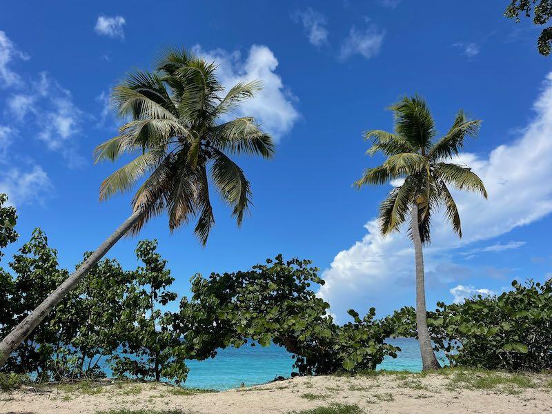


So as I mentioned, I absolutely love Honeymoon beach. The views are gorgeous, as you can see, but it’s also a great place to snorkel. And there are so many fish! If you are interested in snorkeling and seeing numerous species of fish, including blue tang, parrotfish, sergeant major and more, simply access the water at the far end of the beach to your left if you are looking at the water. That’s where the reef is located. Be cautious though, because there is usually a small current that pulls you to your left.
Want to walk to Honeymoon from the ferry dock? The map below shows you how to do so.

Brings tears to my eyes. When I lived there a lot of years ago, the walk to Salomon was my favorite. This brings back so many fond memories, feeling the rocks under my feet, the full sun on my shoulders, and the sting rays in the crystal clear water swimming close enough to touch. Thank you so much.
Pingback:A True Look at the Caneel Bay Beach Club - Island Tidbits
Pingback:Take a Hike on St. John - Explore STJ